- Details
- Written by: Blake Raab (N4BWR)
- Category: Balloons

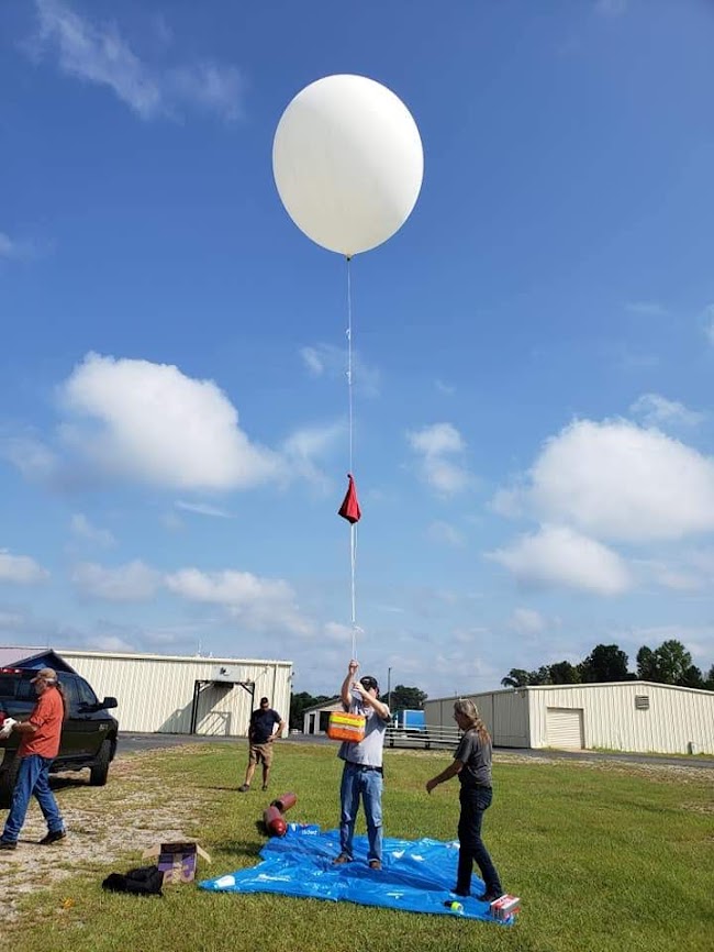
Our weather balloon launch is still a go for 7/10/2021. Current predictions have us near Oxford, and some are in the National Forest. For that reason, we will be tying 100 feet of line between the parachute and the payload. The thinking is that, if the parachute gets caught in a tall tree, the payload may still fall out and be within reach.
We will arrive at the VFW Fairgrounds in Carrollton at 9 AM and plan to launch at 10. Forecasts are still sketchy, but seem to be indicating at least scattered rain or thunderstorms. We will get the payload prepared to the point of being ready to tie it off and take the first opportunity to safely inflate, checking the radar to make sure there is no lightning in the vicinity. If there is, we may wait it out for a short time.
It's going to be an interesting day. The chase and recovery are always an adventure. Be prepared for muddy Alabama county roads, hiking, dense forests, and a recovery in tall trees! We will have plenty of stories to tell. If you have any questions about our plans, you can email
I have created a recovery team group text for us to maintain communication and easily exchange things like the coordinates of the estimated landing site. If you would like to be in on that group text and have not already told me, please email
Flight Day Resources:
- ICS-205 Incident Radio Communications Plan - For a list of the frequencies used for tracking the balloon and communication
- N4BWR's Weather Balloon Trajectory Map - Updated at least every morning with the latest prediction for launch day. After 8 AM on 7/10, that will be the operational map for launch day.
- Tracking of W4FWD-11 on aprs.fi - You can use this site on any computer or mobile device to track the flight of the balloon in real time. Click the balloon icon to see details, including altitude. You can also click on any of the previous red dots on its track for the same information at that point.
- Live Tracking Alongside Prediction - If I remember to update this file (which is a big "if"), you will be able to view the current flight path along with that day's prediction in the Google Earth app on your device. As of the time of this writing on 7/9, the predicted flight path shown in the file is for a flight we had last year.
- Find Terminal Coordinates, Given a Bearing and a Distance - This is a fun one. I have found a highly accurate method to pinpoint where the balloon will land once actual burst has happened by taking the compass heading and distance between predicted burst and predicted landing and applying that once actual burst has happened. This is the site where I will be plugging in the actual burst point and the predicted distance and heading to find the endpoint. I will certainly be announcing this information over our text group and any radio frequencies we're using at the time, but will probably also let everyone know that morning what the predicted distance and heading is so you can plug that in yourself.
- Details
- Written by: Blake Raab (N4BWR)
- Category: Balloons
POSTPONED - Next available launch date is 7/10/2021
It's that time of year again. The West Georgia Amateur Radio Society will be launching a weather balloon on June 19th from the VFW Fairgrounds in Carrollton. We will plan to meet at 9 AM to begin preparation and launch whenever we are ready.
The balloon will carry a device transmitting APRS data so we can track its position and altitude in real time. Because it will be received by stations that can then port the data to the APRS-IS network, you can watch the balloon's progress along with us at this link. It will also carry a crossband repeater so we can communicate with each other through the balloon as it flies. It's always a good idea to get your antenna as high as possible for the best range. How about 20 miles high? :)
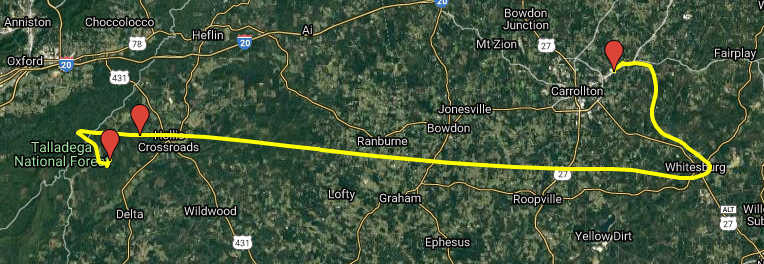
Before we launch, we will have a very good idea of what the balloon's specific path will be on that day. We obtain this information by using the Cambridge University Space Flight Predictor. We will have a briefing in the morning and then the chase will begin. Although weird weather patterns have been making the predictions sporadic, I believe the balloon will land in Alabama.
ICS-205 Incident Radio Communications Plan
Follow the West Georgia Amateur Radio Society on Facebook for more information and updates.
- Details
- Written by: Blake Raab (N4BWR)
- Category: Balloons
Launch day is here! We will be meeting at 9 AM at the VFW Fairgrounds (1625 Bankhead Highway, Carrollton GA). We plan to launch around 10, or whenever everything is ready. See this link for the current flight prediction. Keep in mind that varying ascent or descent rates will stretch or compress that part of the path, but the general shape of the flight prediction is what to watch. Take a look at the predicted burst point and landing site. The distance between them is 3.035 miles, and the heading from burst to landing is 230.58 degrees. Once we know the actual burst point, we can get very close to the landing site before it lands by using this tool to calculate that point based on distance and heading.
We will begin communications on the W4FWD repeater (146.640, negative offset, 131.8 hertz tone), but will quickly switch to the crossband repeater on the balloon (Uplink: 145.600, Downlink: 445.450, 131.8 hertz tone on both). We may use the balloon uplink frequency for simplex communications on the ground at the landing area. The N4THM repeater is also a good alternative (146.865, negative offset, 131.8 hertz tone).
You can track the balloon on aprs.fi here. In that link, I've set the track tail length to three hours to cover the whole flight. If you would like a way to track the balloon alongside the prediction on your mobile device, you can click here, save the KMZ file to your device, and open it in the Google Earth app.
- Details
- Written by: Blake Raab (N4BWR)
- Category: Balloons
This event has been canceled due to weather until a date yet to be determined. Watch this space for updates
Once again, the West Georgia Amateur Radio Society is planning to launch a pico balloon. A pico balloon is one that can travel thousands of miles, and even around the world, with a very small payload that transmits the balloon's location. Ours will be using WSPR on 20 meters.
One major difference between the upcoming flight and the last one is that we'll be using an SBS-13 balloon from Scientific Balloon Solutions instead of a mylar party balloon. The major benefit is that this is a super pressure balloon designed to last longer. I have recently read of other flights of this type that made four laps around the earth.
Another difference is that we will be using hydrogen. This will allow us to achieve the same amount of lift with a lower gas volume. This will put less of a strain on the balloon.
Launch is scheduled for the morning of March 14th, but weather forecasts are not looking good. We'll have to see what happens as the date gets closer.
